Click Here to View This Page on Production Frontend
Click Here to Export Node Content
Click Here to View Printer-Friendly Version (Raw Backend)
Note: front-end display has links to styled print versions.
Content Node ID: 394286
Since the advent of head-up displays (HUD) then enhanced vision systems (EVS) in business jets in 2001, aircraft manufacturers have pushed for technological advances that someday will allow pilots to fly all the way to touchdown on the runway without looking outside the airplane with natural vision.
The FAA has already paved the way for this technological development with the enhanced flight vision systems (EVFS) rules that it published in 2016. The new rules make it possible for pilots flying properly equipped aircraft to land in extremely poor visibility using a HUD and EFVS, essentially flying to the touchdown and rolling out while looking through the HUD at terrain and the runway and airport environment at images generated on the HUD and not by viewing the actual outside world shrouded behind the fog.
Aircraft manufacturers are eager to develop equipment that meets the new FAA regulations, with Bombardier, Dassault, and Gulfstream all planning to deliver an EFVS-to-land-capable system. Interestingly, the new rule does mention a technology that has been a long time coming, called “combined vision system” (CVS) as one possible solution for EFVS-to-land. The rules also seem to preclude using a PFD and de facto require a HUD.
On its way to achieving that capability, Dassault is first to come out with a CVS and certified its version—FalconEye—in October 2016 in the Falcon 2000 and 900 then in the 8X in early 2017. Dassault engineers are planning on making FalconEye compliant with the new EFVS regulations, around the 2020 time frame. FalconEye is based on an Elbit HUD and EFVS camera.
Bombardier and Gulfstream both equip their large-cabin jets with Rockwell Collins HUDs. Bombardier’s new CVS on the Global 5500 and 6500 is based on the Rockwell Collins HUD and camera system. Gulfstream’s EFVS installations are a combination of a Rockwell Collins HUD and a cooled Kollsman (Elbit) camera.
Work on FalconEye began in 2011, led by Arnaud Turpin, FalconEye development leader. Turpin and his team didn’t just design a traditional EFVS but planned all along to bring the first CVS to market, and FalconEye became the first CVS to achieve EASA and FAA certification.
Following FalconEye certification in 2016, the next step for Dassault was certification for EFVS to 100 feet operations in the 8X, which was expected at about the time this issue went to press, and this is expected to follow for the 2000/LXS and 900LX later this year. EFVS to 100 feet is the capability under current FAR 91.175 regulations allowing pilots to fly HUD-equipped airplanes to 100 feet before switching to natural vision to complete the landing.
CVS To Land
Eventually, Dassault plans to certify FalconEye-equipped jets for “CVS to land” operations, which means pilots could fly an approach and land without using natural vision to see the runway, although there will be minimum visibility requirements. Essentially, Dassault is aiming to create a new HUD-enabled capability, which it calls “equivalent visual operation” or EVO, allowing pilots to land safely at all types of airports in all kinds of weather and without the need for expensive added equipment, time-consuming training, and operational limitations that come with Cat II and III approaches.
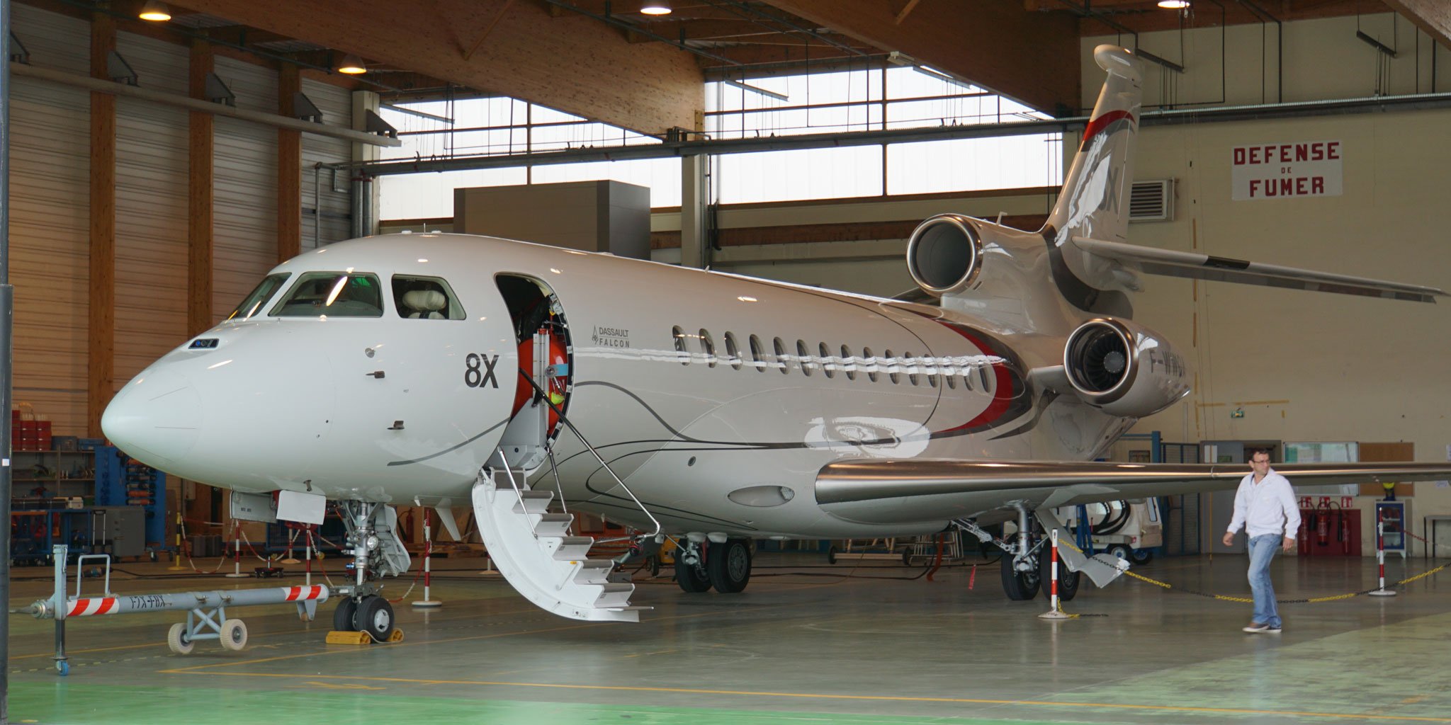
Although FalconEye is an option on new Falcon jets, most buyers, especially of the 8X, are choosing the new HUD. On the new 6X, FalconEye will be standard equipment. Dual HUD installations will also be available for the 8X and 6X and will be part of the requirements for Dassault’s CVS-to-land capability.
The benefits of FalconEye aren’t just in facilitating IFR approaches but more importantly in improving pilots’ situational awareness, because it combines live EVS imagery with database-driven SVS imagery on a HUD.
Dassault’s work on CVS isn’t the only such effort. Honeywell has successfully demonstrated CVS on a head-down display (primary flight display), with the EVS and SVS imagery combined together—ie., overlaid conformally—a tremendously difficult challenge. Pilots who have flown the Honeywell CVS were able to land well within the tight parameters of a specific box near the runway touchdown zone almost every time, with excellent repeatability.
The Rockwell Collins HUD on the Bombardier Global 6000 and its HGS 3500 compact HUD on the Embraer Legacy 450 and 500 can display both EVS and SVS imagery, but not at the same time. Rockwell Collins’s CVS for the Global 5500 and 6500 will offer conformal overlay of EVS and SVS, and this system is expected to enter service with the upgraded Globals around 2020.
In designing FalconEye Dassault engineers had to decide whether to try to combine EVS and SVS a la Honeywell and Rockwell Collins by overlaying the imagery conformally or to devise a different solution. Overlaying the imagery is challenging because SVS is derived from a terrain database, and the data need be off only slightly for the SVS image not to be conformal, ie, not to match exactly the real-time EVS image, which comes from onboard sensors and cameras.
Dassault’s CVS Solution
The FalconEye solution was to give the pilot leeway in how to display EVS and SVS imagery on the HUD and to allow both to be displayed at the same time, but not overlaid.
As a result, FalconEye allows the pilot to adjust a horizontal split line between EVS and SVS, moving the line up or down the HUD combiner depending on the particular outside environment. For example, during the approaches that I flew at Chambery, I could set the split line on the horizon so I could see the visually obscured mountains depicted clearly on the SVS. Below the split line I could see the EVS imagery of the town, lake, roads, and airport.
But what if I want to see terrain surrounding the immediate airport environment on SVS?
Dassault engineers cleverly figured out how to include the benefits of EVS even when SVS is the predominant image displayed on the HUD. What they did was carve out a conformal runway clear zone around the airport, so even if the airport is within the SVS depiction, the selected destination runway is clearly visible via EVS inside the clear zone.
The FalconEye system consists of an Elbit HUD with a large field of view of 40 degrees horizontal and 30 degrees vertical and 1,280 pixel horizontal and 1,024 pixels vertical resolution. Maximum brightness is 3,000 foot-lamberts, which ensures that HUD symbology is bright enough even during the daytime. FalconEye, in fact, can be used as a primary flight reference during all flight phases and all allowable types of operations.
The EVS side of FalconEye consists of an uncooled Elbit multi-sensor camera mounted on top of the airplane’s nose. The visible cameras are tuned for light detection during the day, while the night sensor is optimized for detecting lights at night. The visible cameras also can “see” LED lights, which are increasingly found at airports around the world.
The thermal (infrared) sensor generates images by detecting latent heat in the terrain, and this is aided by the long-wave nature of that sensor, according to Turpin.
Combined, these six sensors capture details in the visible wavelength and near- and long-wave infrared wavelengths. The output from the sensors is mixed and matched or fused via carefully designed algorithms, one for the thermal sensor and terrain imagery and one for the lights sensors. These two outputs are then fused again to deliver the image that is sent to the HUD and also to the MFD, acting as a HUD repeater (duplicating the HUD image on a head-down display).
High and Low
FalconEye provides two functional modes selectable by the pilot: high mode for high visibility conditions and low mode for low visibility. The high mode is better for night operations, especially with few clouds and during moonlight.
While infrared sensors in general can’t see through moist clouds and fog, the FalconEye camera does a better job than earlier cameras that use short- and medium-range infrared sensors, according to Turpin. “When there is haze or fog with this technology,” he said, “we see through [it] better than the previous technology because we have dedicated sensors to see the terrain and dedicated sensors to see the lights. We don’t do a compromise between both. It’s better to see the terrain and the lights compared to previous generation, but it’s still not magical. When there is a big cloud, you don’t see through it.”
“There is a big gap between the old system, which is a simple infrared sensor, and this system,” said Falcon chief test pilot Frédéric Lascourréges. “With the previous system sometimes you could say it’s a little bit of gambling when you do the approach. You don’t know if it will help, if it will do nothing, or sometimes if it will just clutter your display. With this system, most of the time it’s an improvement.”
He pointed out that the pilot can simply remove the video on the HUD, leaving the normal flight symbology and eliminating the EFVS information, with the push of a button on the sidestick. “You couldn’t do this with the previous system; you would have to decrease the brightness.”
The sensors on the new camera also help pilots see clouds at night, which is helpful for thunderstorm avoidance. “With the previous system it was not very good to see the CBs [thunderstorms],” he said. During a trip to Europe from the U.S., he was able to use the EFVS to see the coast of Great Britain while still well offshore, from FL410, also something not possible with the earlier system. “It really gives you a very good situational awareness all the time.”
SVS and EVS Setup
SVS maximum range is 75 nm, and the system uses three databases provided by Jeppesen, for navigation, obstacle, and terrain data. SVS shows a depiction of the outside view based on those databases, including land, water, obstacles, and airports. Of course images on the HUD SVS are in shades of green, not multi-colored as depicted on the PFD.
FalconEye gives pilots many choices on how to set up the SVS and EVS imagery on the HUD, but also helps pilots manage how the HUD displays in various phases of flight. The pilot is offered symbology designed for taxi, takeoff/go-around, cruise (which includes climb and descent), approach, and rollout.
Each phase is optimized to give the pilot the necessary information on the HUD, while eliminating superfluous information. For example, in taxi mode, there are no speed/altitude tapes or attitude information. The flight-path vector (FPV) is shown, to aid taxiing (but below the horizon line), as is groundspeed and heading. “We don’t want to clutter the HUD too much,” said Turpin, “otherwise pilots can’t see outside.”
Most phases have a basic and a secondary mode, selectable using a HUD/symb button on the sidestick. The default is basic mode, which is the uncluttered view for each phase. In taxi phase, pushing the sidestick button changes the view to full HUD symbology, essentially the equivalent of the takeoff/go-around phase.
“For takeoff there’s only one mode,” explained Lascourréges, “with a vertical scale on speed and altitude. You want to see rapid changes, and it’s very dynamic. As soon as you have a dynamic situation where speed and altitude changes rapidly, it’s easier to see with the scales.”
In normal operations, the HUD moves from phase to phase automatically. For example, after taxi and lined up on the runway, the HUD moves to takeoff/go-around phase when power levers are pushed up to full power. After takeoff, when landing gear is retracted and slats/flaps zero selected, the HUD goes to the cruise phase, which includes most symbology but replaces the airspeed and altitude vertical scales with simpler numeric displays to cut down on clutter.
In all modes, Dassault no longer places the HSI on the bottom of the HUD because it added no useful additional information, something that Dassault engineers knew from HUDs on Dassault military jets. “We have been developing HUDs for fighters for years,” said Lascourréges, “including for low-altitude terrain following. We have a good idea of what we need in a HUD. When we developed the Rockwell Collins HUD [on earlier Falcons], Dassault engineers and pilots didn’t want the HSI. It’s useless and was imposed by the European certification authorities. For us, it only gives clutter, and when you’re trained on this type of HUD, you don’t need the HSI.”
Everything that the HSI does is already replicated elsewhere on the HUD, and removing it cleans up the view considerably. The HSI is always available on the PFD. Earlier Falcon HUDs removed the HSI only when flying an ILS approach.
Runway Depiction
Airports in SVS within 75 nm are shown as ICAO labels on virtual 1,000-meter-high poles planted in the center of the airport, but the destination airport has a box around its label.
When approaching the destination airport, the flight-planned runway shows up in the SVS as a “symbolic runway,” a 1,000-meter-high pole topped by a QFU (magnetic orientation) or runway axis number. This helps the pilot visualize the location of the runway end, because the pole is placed at the threshold.
As the airplane gets closer to the airport, the view switches to a conformal runway symbol, which is always shown independent of whether EVS or SVS is selected where the airport is located.
To help pilots anticipate the location of approach lights during low-visibility approaches, the HUD displays ALS (approach light system) markers at 1,000, 2,000, and/or 3,000 feet, matching the ALS at the particular airport. “It’s helpful to know where to look for the approach lights,” said Turpin.
The runway symbology on the new HUD displays for any type of instrument approach, including GPS approaches, unlike the earlier HUD, which only showed the runway symbol for ILS approaches.
Pilots can remove the conformal runway symbology by pushing the basic/secondary “HUD/symb” button on the sidestick, but the runway automatically disappears at 80 feet anyway, forcing the pilot to use natural vision to view the runway during landing and not rely on the EVS imagery.
SVS Versus EVS
Two modes are available to the pilot: angular or min range. The angular mode is for all phases of flight except approach. In this mode, everything that is under a split line that separates SVS and EVS, set at a fixed -10 degrees below the horizon, is EVS or natural vision while above that split line SVS is shown. “We want to display SVS in the head-up display,” said Turpin, “but it must be as a complement to the eyes. We want to be able to remove one part of the SVS.”
This is useful, especially at the beginning of the approach where the pilot can use SVS to see terrain features in the distance. But during the approach, the split line between EVS and SVS reverts to min range, which is a distance instead of an angle. Essentially, as the aircraft descends toward the ground before the approach, the nose masks the view below the aircraft and the EVS camera can’t see it, although SVS can show this portion of the area around the airport. Closer to the runway, the masking doesn’t really matter anymore so the SVS is removed from the bottom of the HUD.
The portion of the airport surrounding the runway, even if depicted in SVS, always is displayed inside an SVS runway clear zone or cutout. The clear zone varies in size depending on the decision altitude (smaller for a low altitude, larger for a high decision altitude or steep approach). The bottom of the split is the range clear zone, in which SVS is not allowed to intrude, and this merges with the runway clear zone during the approach, so that the close-in terrain, the approach lights, and the portion of the airport surrounding the runway always shows up in EVS.
Understanding how this works is much easier when flying with the FalconEye HUD.
Flying the FalconEye CVS
To prepare for flying the 8X (my second time), I again spent about an hour in the 8X full-flight simulator at FlightSafety International’s Le Bourget learning center outside Paris. Lascourrèges sat at the instructor station while I flew left seat, accompanied by Hubert Giraud, Dassault head of flight operations, Flight Test Directorate, in the right seat.
The idea was to reacquaint myself with the 8X and get more used to flying with the HUD (which I prefer to do anytime I’m flying a HUD-equipped airplane). We practiced flying from Chambery Airport in Savoie, which is where the next day’s night flight would take place. For a change, I wished for poor weather conditions for the actual flight.
We flew two ILS approaches to Runway 18 at Chambery, the first in clear day conditions followed by a missed approach and the second at night with 3 km visibility.
Flying the 8X using the HUD makes keeping on target much easier. During the first takeoff, I found myself looking at the head-down PFD and I wasn’t doing a good job staying on altitude and heading, but when I switched to the HUD, the 8X settled down smoothly. I practiced flying steeper flight paths on approach and using the TCS button on the sidestick to move the flight director cue down to match the FPV, an easy way to fly a steep approach.
During both approaches, I viewed the runway outline on the EVS clear zone. Putting the FPV right on the touchdown point made landings easy. During the night landing, I couldn’t see any of the simulated mountainous terrain using natural vision when looking around the HUD combiner glass, which reminded me how helpful it was to have SVS on the HUD.
The next day, I tried out the 8X system integration test station at Dassault’s flight test operation at the Istres-Le Tubé Air Base military flight test facility in southern France. This was much harder to fly compared to the simulator or the real airplane, but good preparation for the real flight.
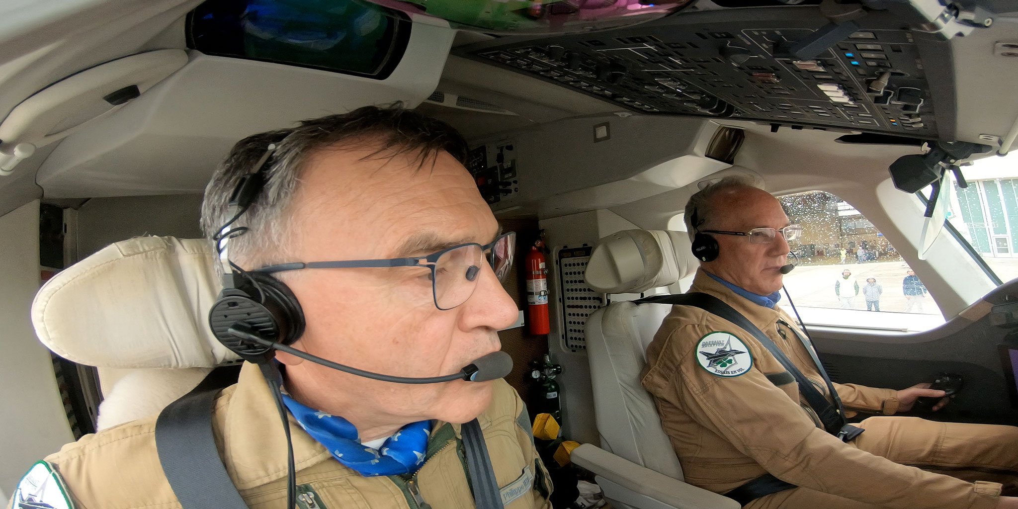
After a thorough preflight briefing and a battery-recharging nap and a light supper with the flight test crew, we climbed aboard F-WWQA for the night’s adventures. I flew left seat, the only seat with the FalconEye HUD, while Dassault project test pilot Philippe Rebourg flew right seat. We were accompanied by test pilot Bruno Ferry and photographers documenting the flight.
It was still light out when we departed Istres for a quick climb to 15,000 feet and some handling qualities refamiliarization flying. This included some steep 60-degree banks and slow flight with full slats/flaps and gear down. To see how the HUD helps the pilot in an upset situation, I flew a steep climbing bank at about 80 degrees, the recovered after I saw the HUD’s clear, uncluttered guidance pointing out which way to recover.
After that, I descended to 2,000 feet and we flew north past Istres along the Rhône Valley while viewing the SVS, EVS, and CVS modes on the HUD. I played with the split line between EVS and SVS and used both to identify the 250-meter tall powerplant chimney in Aramon.
It was getting dark by the time we climbed to FL240 for the short flight to Chambery.
Although most of the clouds were high enough at 3,500 feet agl to make it easy to spot the airport next to Le Bourget Lake, visibility was low and it was impossible to see with natural vision the mountains in the deepening darkness. Scattered to broken clouds occasionally obscured the ground, and lights from the town below us peeked through, blinked out, then reappeared.
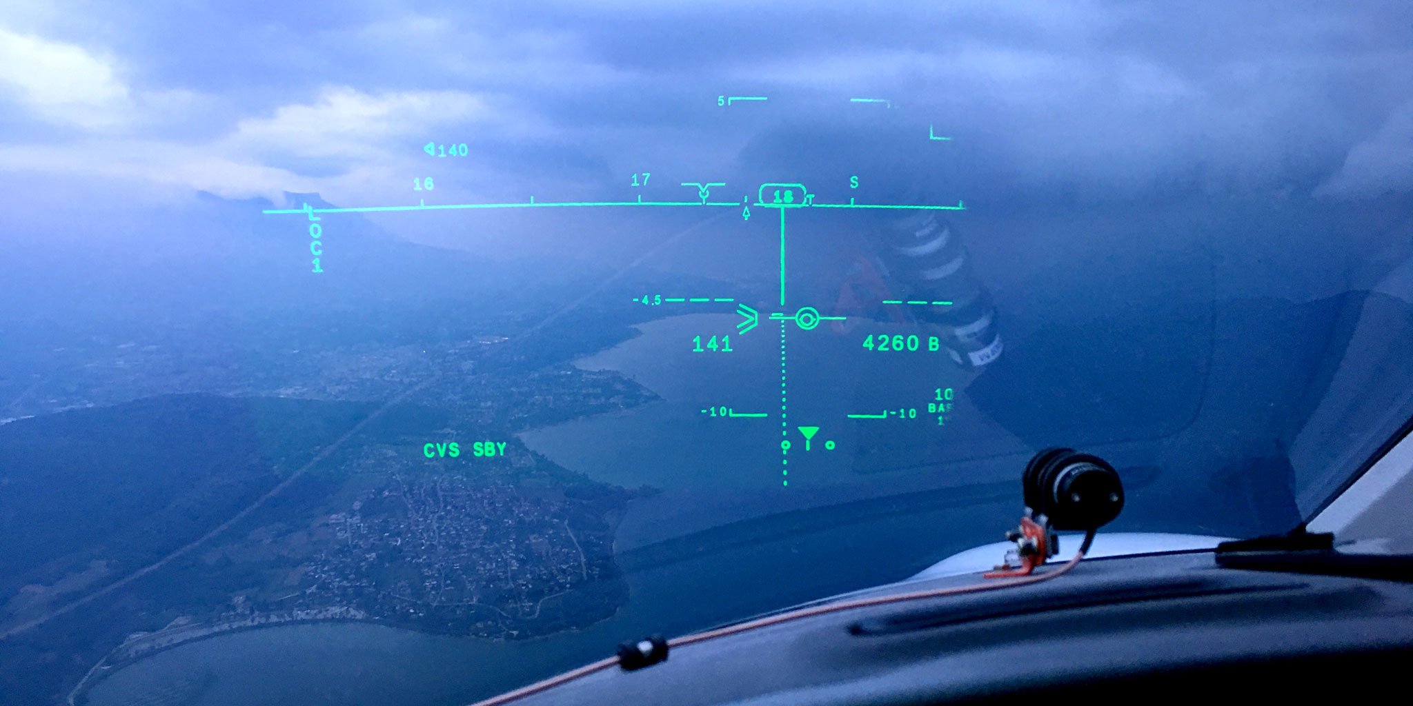
During our first approach, the ILS to runway 18, thanks to FalconEye, I could easily see the mountains, the lake, the town, and most importantly, the runway awaiting our landing. After landing at Chambery, we dropped off one of the photographers so he could shoot some photos and video of us from the ground during the upcoming maneuvers.
During the flight around Chambery, I flew four approaches, including ILSs to minimums on Runway 18, circling approaches to Runway 36, and missed approaches.
I tried many variations of adjusting the split between EVS and SVS during the approaches, and observed the benefit of the airport clear zone with EVS while SVS showed the nearby mountainous terrain. Flying in the airplane with FalconEye made its benefits apparent, and I instantly understood how the split between EVS and SVS helped me maintain situational awareness while flying in this mountainous region. Having SVS at the top of the HUD seemed completely natural, because the SVS depiction of terrain and mountains in the distance contrasted perfectly with the close-in view using EVS on the bottom of the combiner.
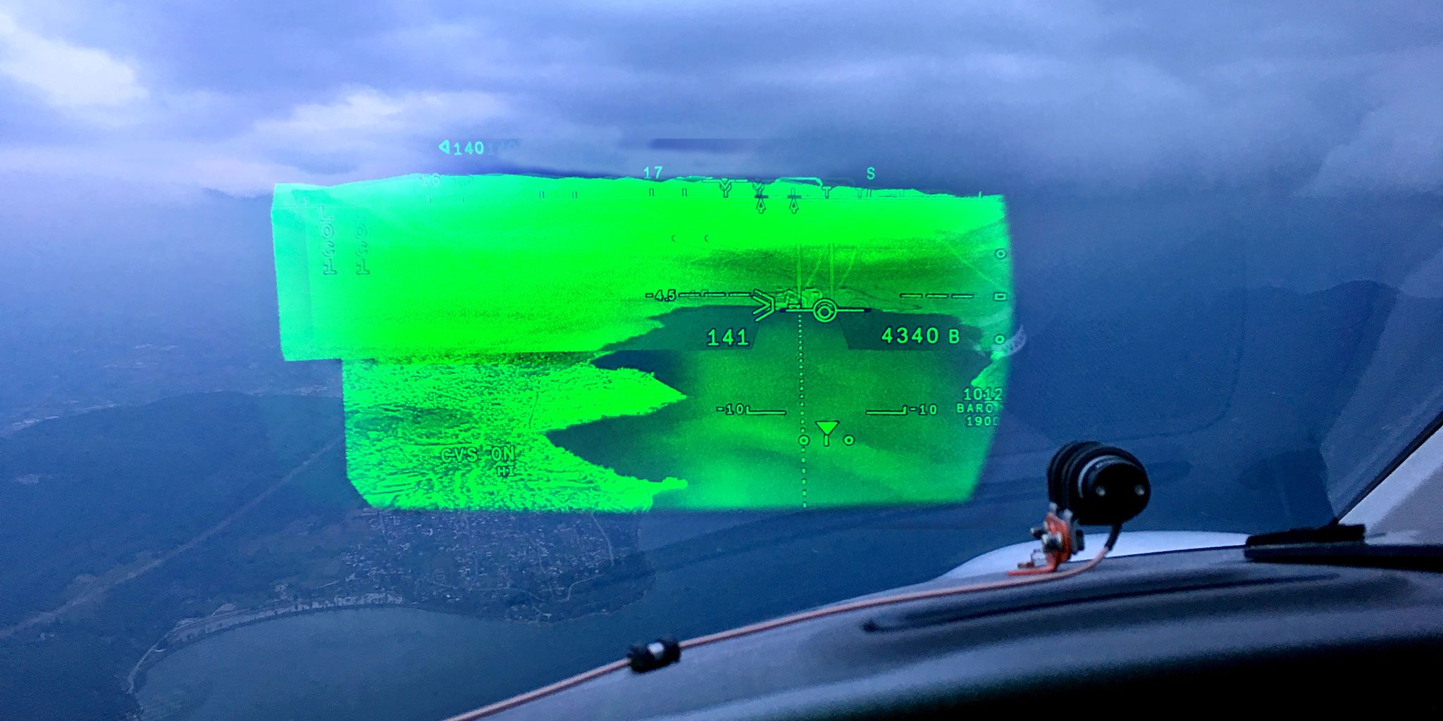
With the four visible-light sensors and the infrared sensor, the EVS mode depicted clouds below us in different colors, some gray and dark and others white and green, depending on which sensor was providing the information to the HUD.
In the runway clear zone, I could easily see the runway boundaries and edges, approach light bar symbols (which matched the location of the approach lights so the pilot knows where to look), and runway lights. When flying toward the airport, the runway location is easily visible. I could follow a dashed lead-in line to the end of the runway, which was also identified by the 1,000-meter-high pole topped by the runway’s magnetic orientation QFU. As we flew closer to the airport, I could see in the EVS clear zone the clearly marked borders of the runway.
Maneuvering around Chambery Airport requires a few quick turns and careful altitude management. For example, after the missed approach following the ILS 18, it is necessary to make a tight 180-degree turn by flying left to a heading of 80 degrees then immediately right to 260 degrees, then flying back over the runway. To land on runway 36, we had to fly the ILS approach to 1,690 feet then follow prescribed flight tracks around a course-reversing holding pattern to line up with the runway.
While flying the final circling approach, I turned a bit late from the initial leg to the downwind leg, and I could see a hill in front of but still below us in the SVS. We would have cleared it by a few hundred feet, which I could see by looking at the flight path vector pointing above the terrain depicted on the SVS imagery, but for maximum safety I turned back toward the airport and away from the terrain. Being able to see that clearly even though the visibility was poor contributed greatly to situational awareness and safety.
After our final landing, we picked up the photographers. Rebourg and Ferry switched seats, and I flew the rest of the flight with Ferry in the right seat. We taxied back and took off on runway 36 for the ferry flight back to Istres.
After flying with FalconEye for more than two hours in the 8X, I came to appreciate the massive improvement in situational awareness but also how it helps pilots fly more smoothly and with greater safety during low-visibility operations, especially when high terrain is involved.
As the sun disappeared behind the mountains surrounding Chambery Airport in Savoie, France, we continued the ILS approach to Runway 18 in a Dassault Falcon 8X equipped with the FalconEye head-up display (HUD). Although most of the clouds were high enough at 3,500 feet agl to make it easy to spot the airport next to Le Bourget Lake, visibility was low and it was impossible to see with natural vision the mountains in the deepening darkness. Scattered to broken clouds occasionally obscured the ground, and lights from the town below us peeked through, blinked out, then reappeared.
But thanks to the FalconEye HUD, from the left seat I could easily see the mountains, the lake, the town, and, most important, the runway awaiting our landing.
Dassault engineers have been working on FalconEye since 2011, and it was certified in 2016 in the Falcon 2000 and 900 then in the 8X in early 2017. By year-end, Dassault expects to receive certification for “EFVS to 100 feet” operations in the 8X, then in the 2000/LXS and 900LX in the first half of 2019.
Enhanced flight vision system (EFVS) to 100 feet is the capability under current regulations allowing pilots to fly HUD-equipped airplanes to 100 feet before switching to natural vision to complete the landing. Eventually, Dassault plans to certify FalconEye-equipped jets for “EFVS to land” operations, which means pilots could fly an approach and land without using natural vision to see the runway, although there will be minimum visibility requirements.
Essentially, Dassault is aiming to create a new HUD-enabled capability, which it calls “equivalent visual operation,” or EVO, allowing pilots to land safely at all types of airports in all kinds of weather and without the need for expensive added equipment, time-consuming training, and operational limitations that come with Cat II and III approaches.
Although FalconEye is an option on new Falcons, most buyers, especially those opting for the 8X, are choosing the new HUD. On the new 6X, FalconEye will be standard equipment. Dual HUD installations will also be available for the 8X and 6X.
Situational Awareness
The benefits of FalconEye aren’t just in facilitating IFR approaches, but more importantly in improving pilots’ situational awareness. For the first time, it combines live enhanced vision system (EVS) imagery with database-driven synthetic vision system imagery on a HUD. FalconEye is the first combined vision system (CVS) to achieve EASA and FAA certification.
Dassault’s work on CVS isn’t the only such effort. Honeywell has successfully demonstrated CVS on a head-down display (primary flight display), with the EVS and SVS imagery combined together—overlaid conformally—a tremendously difficult challenge. Pilots who have flown the Honeywell CVS were able to land well within the tight parameters of a specific box near the runway touchdown zone almost every time, with excellent repeatability.
The Rockwell Collins HUD on the Bombardier Global 6000 and its HGS 3500 compact HUD on the Embraer Legacy 450 and 500 can display both EVS and SVS imagery, but not at the same time. The CVS on the new Global 5500 and 6500 is fully conformal.
In designing FalconEye Dassault engineers had to decide whether to try to combine EVS and SVS by overlaying the imagery conformally or to devise a better solution. Overlaying the imagery is hard because SVS is derived from a terrain database, and the data need be off only slightly for the SVS image not to be conformal—not matching exactly the real-time EVS image, which comes from onboard sensors and cameras.
The FalconEye solution was to give the pilot leeway in how to display EVS and SVS imagery on the HUD and to allow both to be displayed at the same time, but not overlaid. As a result, FalconEye allows the pilot to adjust a horizontal split line between EVS and SVS, moving the line up or down the HUD combiner depending on the particular outside environment. For example, during the approaches that I flew at Chambery, I could set the split line on the horizon so I could see the visually obscured mountains depicted clearly on the SVS, and below the split line I could see the EVS imagery of the town, lake, roads, and airport.
But what about seeing terrain surrounding the immediate airport environment on SVS? Dassault engineers cleverly figured out how to include the benefits of EVS even when SVS is the predominant image displayed on the HUD. What they did was carve out a conformal runway clear zone around the airport, so even if the airport is within the SVS depiction, the selected destination runway is clearly visible via EVS inside the clear zone.
The FalconEye system consists of an Elbit HUD with a large field of view of 40 degrees horizontal and 30 degrees vertical and 1,280 pixel horizontal and 1,024 pixels vertical resolution. Maximum brightness is 3,000 foot-lamberts, which ensures that HUD symbology is bright enough even during the daytime. FalconEye, in fact, can be used as a primary flight reference during all flight phases and all allowable types of operations.
The EVS side of FalconEye consists of an Elbit multi-sensor camera mounted on top of the airplane’s nose. The camera is fitted with four day sensors and one night sensor, and these are for detecting lights during the day or night. A thermal sensor is for terrain imaging.
Combined, these six sensors capture details in the visible wavelength and near- and long-wave infrared wavelengths. The output from the sensors is mixed and matched to provide two functional modes selectable by the pilot: high mode for high-visibility conditions and low mode for low-visibility.
Left-seat View
During the flight around Chambery, with Dassault test pilot Philippe Rebourg flying right seat, I flew four approaches, including ILSs to minimums on Runway 18, circling approaches to Runway 36 and missed approaches. I tried many variations of adjusting the split between EVS and SVS during the approaches and observed the benefit of the airport clear zone with EVS while SVS showed the nearby mountainous terrain.
With the five visible-light sensors and the infrared sensor, the EVS mode depicted clouds below us in different colors, some gray and dark and others white and green, depending on which sensor was providing the information to the HUD.
In the clear zone, I could easily see the runway boundaries and edges, approach light bar symbols—which matched the location of the approach lights so the pilot knows where to look—and runway lights. When flying toward the airport, the runway is easily visible, at first identified by a 1,000-meter-high pole topped by the runway’s magnetic orientation number (QFU) to help the pilots find the end of the runway, then as we flew closer to the airport, by the clearly marked borders of the runway.
While flying the final circling approach, I turned a bit late to the downwind leg, and I could see a hill in front of but still below us in the SVS. We would have cleared it, which I could clearly see by looking at the flight path vector pointing above the terrain depicted on the SVS imagery, but for maximum safety, I turned back toward the airport and away from the terrain.
After flying with FalconEye for more than two hours in the 8X, I came to appreciate the massive improvement in situational awareness, as well as how it helps pilots fly smoother and with greater safety during low-visibility operations, especially when high terrain is involved.